Maui, also known as the Valley Isle, is made up of two major mountain ranges and 120 miles of coastline with beaches, valleys, and countryside in between. If you're planning a trip to Maui, be sure to check out our Maui maps.
- Shaka Guide offers eight detailed maps of Maui, including an island-wide overview, regional divisions, and six tour-specific maps highlighting major stops and attractions.
- The maps provide insights into Maui's five distinct regions: West Maui, Central Maui, Upcountry Maui, East Maui, and South Maui.
- These resources assist travelers in planning their trips by highlighting major points of interest, roads, cities, and scenic driving routes.
TABLE OF CONTENTS
We have a total of 8 maps - one island map with major points of interest, roads, and cities, one regional map that breakdown Maui's five regions, and 6 tour maps with major stops and things to do in some of Maui's most popular spots like the Road to Hana and Haleakala.
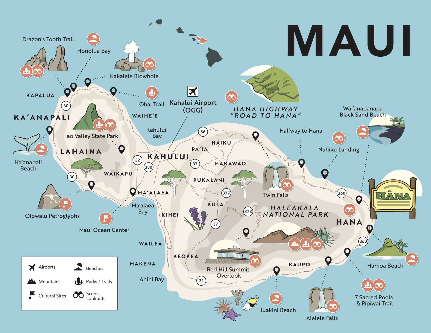
Maui Island Map
In the below map, you'll find an overview of Maui's major towns, cities, and points of interest including airports, beaches, mountains and parks, trails, scenic viewpoints, and cultural sites.

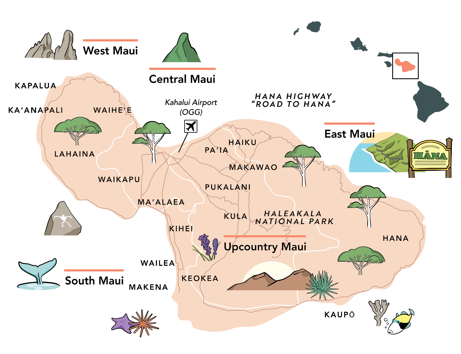
Regional Maui Map
Maui has five distinct regions:
- West Maui
- Central Maui
- Upcountry Maui
- East Maui
- South Maui
West Maui is home to the major resort areas of Kaanapali and Kapalua, as well as the seaside town of Lahaina. Central Maui is best known for Kahului - where Maui's major airport is located and the starting point of the Road to Hana. In upcountry Maui, you'll find Haleakala Crater and its many hikes and scenic viewpoints. East Maui is most famous for the Road to Hana including Hana Town and Waianapanapa State Park. And finally, South Maui has some beautiful beaches and a beloved snorkel spot - Molokini Island. Check out the map below to learn more!

Tour Maps
Looking for things to do in a specific part of the island? Check out our Maui tour maps. We have maps with major stops on the Road to Hana, Haleakala, and West Maui. These maps follow our Maui tour routes. Download the Shaka Guide app to check out our tours. We'll guide you to all the stops on these maps with stories and music along the way.
Road to Hana Maps - Classic, Loop, and Reverse Routes
There are three ways to take the Road to Hana. The classic way, which starts in Kahului and ends in Kipahulu past Hana then returns the same way you came. The loop route which travels past Hana to Kula in a "loop." And, the reverse route which starts at the "end" of the road to Hana and travels backways towards Kahului. Check out the maps below to decide which option is best for you.
Road to Hana Mile markers
Classic Road to Hana

Loop Road to Hana
Reverse Road to Hana

RELATED: Road to Hana Maps
Haleakala Maps - Sunrise and Sunset Routes
Whether you choose to visit Haleakala for sunrise or sunset, you're bound to find magnificent views and out-of-this-work hiking trails. Check out the maps below for some of our favorite stops in the park. If you choose to visit at sunrise, we recommend you make your way to the summit first, then hit the stops on the way back. If you're visiting for sunset, spend the day exploring the park and visit the summit last just in time to watch the sun go down.
Haleakala Sunrise Map
Haleakala Sunset Map
RELATED: Haleakala Sunrise to Sunset - Everything You Need to Know
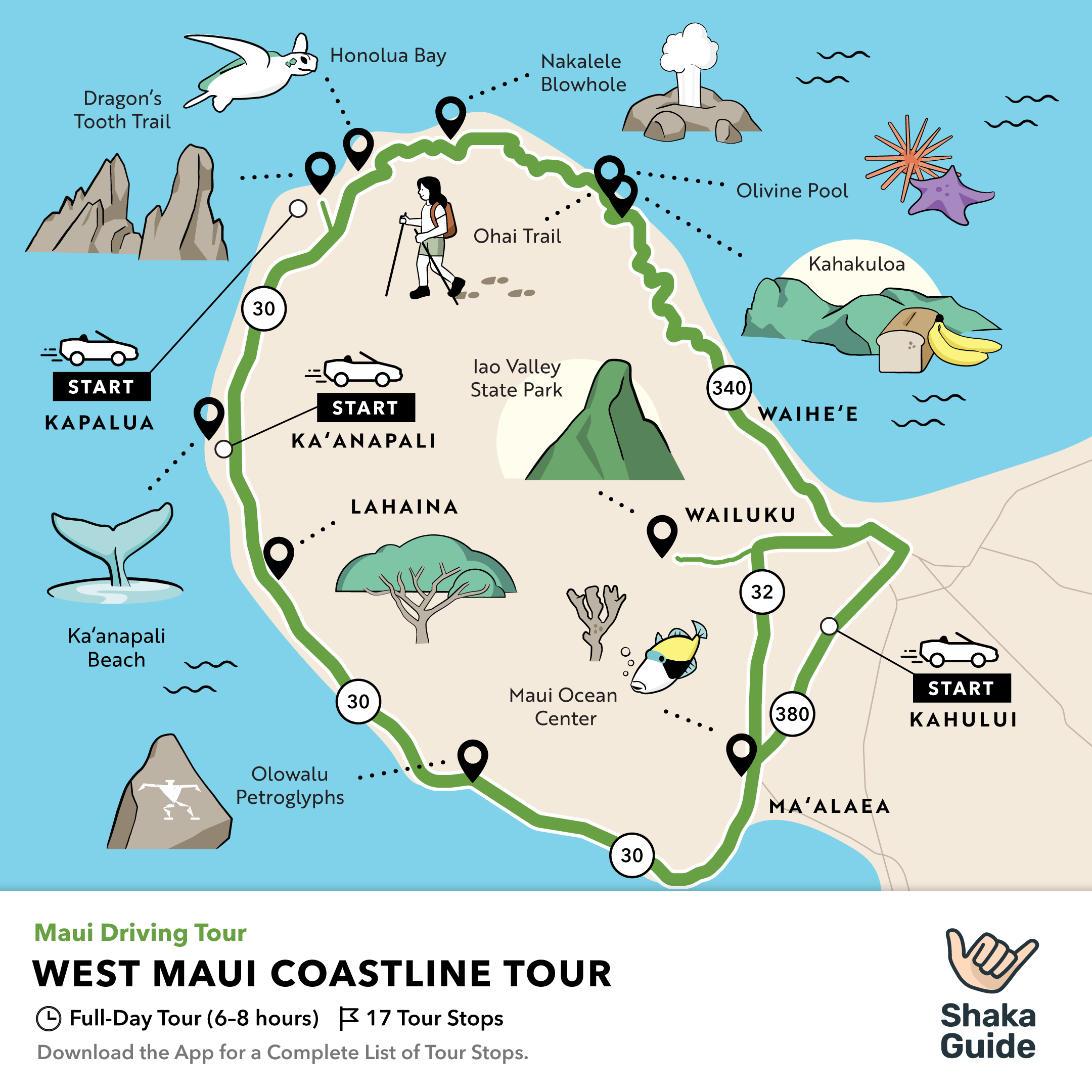
West Maui Coastline Map
Staying in the resort neighborhoods of West Maui? Well, you're in luck! There's so much to see and do just outside your hotel. From the seaside town of Lahaina to the stunning beaches of Kaanapali and Kapalua! Check out our West Maui Coastline Tour for major stops in this area!

Visiting Maui? Download our Maui map packet and start planning your trip!
MAUI TRAVEL GUIDES:
The Ultimate Maui Travel Guide
Which Maui Tour is Right For You?
10 Ways To Be An Eco-Conscious Visitor in Maui
Maui vs Oahu: Which Is Right for You?
MAUI ACTIVITIES:
15 Family-Friendly Activities in Maui
10 Must-Visit Historic Sites in Maui


